
Make a donation
Gear up for your next adventure:
As an Amazon Associate, this site earns from qualifying purchases at no extra cost to you.
Dent du Salentin topographic map
Click on the map to display elevation.
Make a donation
Gear up for your next adventure:
As an Amazon Associate, this site earns from qualifying purchases at no extra cost to you.
About this map
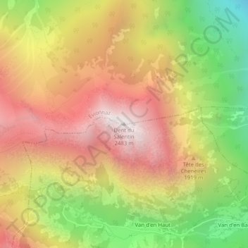
Name: Dent du Salentin topographic map, elevation, terrain.
Location: Dent du Salentin, Evionnaz, Saint-Maurice, Valais, 1922, Suisse (46.15119 6.99592 46.15129 6.99602)
Average elevation: 1,735 m
Minimum elevation: 868 m
Maximum elevation: 2,462 m
Make a donation
Gear up for your next adventure:
As an Amazon Associate, this site earns from qualifying purchases at no extra cost to you.
Other topographic maps
Click on a map to view its topography, its elevation and its terrain.
Lac de Salanfe
Suisse > Valais > Saint-Maurice > Evionnaz
Ce lac est situé dans la commune d’Evionnaz, dans le canton du Valais à une altitude de 1 925 mètres. Situé au pied des Dents du Midi, il est possible d'y accéder à pied depuis Salvan.
Average elevation: 2,049 m