Geolocate

Alstad topographic map

Click on the map to display elevation.

About this map

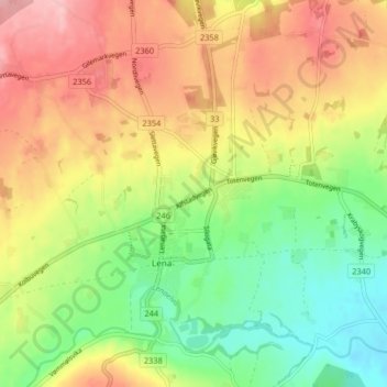
Name: Alstad topographic map, elevation, terrain.

Location: Alstad, Lena, Østre Toten, Innlandet, 2850, Norway (60.66112 10.80030 60.70112 10.84030)

Average elevation: 262 m

Minimum elevation: 195 m

Maximum elevation: 335 m

Gear up for your next adventure:

🥾Trail Running Shoes - Shoes for trail running
🏫Topographic World Globes - 3D physical relief globes to understand global geography
🧼Biodegradable Soap - Eco-friendly outdoor soap
🧢Wide Brim Sun Hats - Maximum coverage for the face and neck while out in the open
🪢Paracord - Multi-purpose survival cord

As an Amazon Associate, this site earns from qualifying purchases at no extra cost to you.