Geolocate

Hellevoetsluis topographic map

Click on the map to display elevation.

About this map
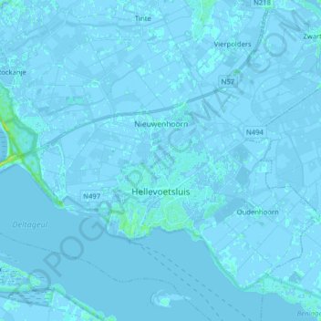
Name: Hellevoetsluis topographic map, elevation, terrain.

Location: Hellevoetsluis, Voorne aan Zee, South Holland, Netherlands (51.80502 4.03984 51.88160 4.19826)

Average elevation: 0 m

Minimum elevation: -6 m

Maximum elevation: 12 m

Other topographic maps

Click on a map to view its topography, its elevation and its terrain.

Gooland

Netherlands > South Holland > Nootdorp

Average elevation: -2 m

Langeraar

Netherlands > South Holland

Average elevation: -3 m

Meije

Netherlands > South Holland > Nieuwkoop

Average elevation: -2 m

Meijendel

Netherlands > South Holland > Wassenaar

Average elevation: 6 m

Weerestein

Netherlands > South Holland > Hillegom

Average elevation: 0 m

Botlek

Netherlands > South Holland

Average elevation: 3 m

Weerestein

Netherlands > South Holland > Hillegom

Average elevation: 0 m

Ankerpark

Netherlands > South Holland > Leiden

Average elevation: 3 m

Waalhaven

Netherlands > South Holland > Rotterdam

Average elevation: 3 m

Middelsluis

Netherlands > South Holland > Numansdorp

Average elevation: 0 m

Coepelduynen

Netherlands > South Holland > Katwijk

Average elevation: 4 m

Broekhuizen

Netherlands > South Holland > Gouda

Average elevation: -1 m

Het Park

Netherlands > South Holland > Rotterdam

Average elevation: 4 m

Gear up for your next adventure:

🩹Wilderness First Aid Kits - Comprehensive medical kits tailored for hiking and remote exploration
🏃Compression Recovery Socks - Reduce leg fatigue after heavy days of elevation gain
🖼️Scratch-off Australia Map - Track the regions and peaks you have explored geographically
📱Shockproof Phone Cases - Extra protection for your smartphone against drops on rocky terrain
🥾Hiking Shoes - Lightweight hiking shoes for day hikes

As an Amazon Associate, this site earns from qualifying purchases at no extra cost to you.