
Plaizac topographic map
Interactive map
Click on the map to display elevation.
About this map
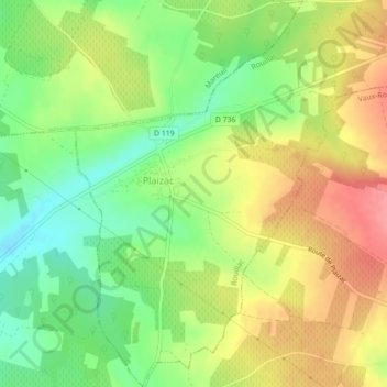
Name: Plaizac topographic map, elevation, terrain.
Average elevation: 95 m
Minimum elevation: 53 m
Maximum elevation: 139 m
Other topographic maps
Click on a map to view its topography, its elevation and its terrain.
Rouillac
France > Nouvelle-Aquitaine > Rouillac
Rouillac, Route de Saint-Jean d'Angély, Monplaisir, Rouillac, Cognac, Charente, Nouvelle-Aquitaine, France métropolitaine, 16170, France
Average elevation: 124 m
Boisauroux
France > Nouvelle-Aquitaine > Rouillac > Boisauroux
Boisauroux, Rouillac, Cognac, Charente, Nouvelle-Aquitaine, France métropolitaine, 16170, France
Average elevation: 137 m