
Pa Deng topographic map
Interactive map
Click on the map to display elevation.
About this map
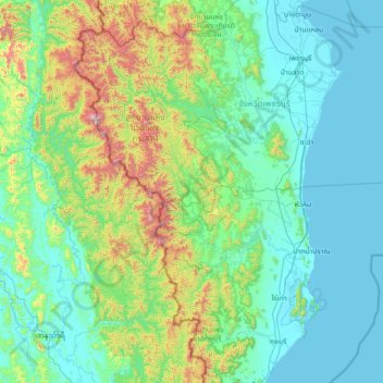
Name: Pa Deng topographic map, elevation, terrain.
Location: Pa Deng, Phetchaburi Province, Thailand (11.91494 98.84128 13.31494 100.24128)
Average elevation: 223 m
Minimum elevation: -1 m
Maximum elevation: 1,458 m
Other topographic maps
Click on a map to view its topography, its elevation and its terrain.
Kaeng Krachan District
Thailand > Phetchaburi Province
Kaeng Krachan District, Phetchaburi Province, 76170, Thailand
Average elevation: 95 m
Kaeng Krachan National Park
Thailand > Phetchaburi Province
Kaeng Krachan National Park, Phetchaburi Province, Thailand
Average elevation: 409 m