
Make a donation
Gear up for your next adventure:
As an Amazon Associate, this site earns from qualifying purchases at no extra cost to you.
Simmern topographic map
Click on the map to display elevation.
Make a donation
Gear up for your next adventure:
As an Amazon Associate, this site earns from qualifying purchases at no extra cost to you.
About this map
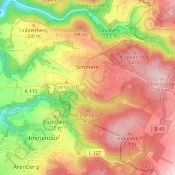
Name: Simmern topographic map, elevation, terrain.
Average elevation: 258 m
Minimum elevation: 108 m
Maximum elevation: 370 m
Make a donation
Gear up for your next adventure:
As an Amazon Associate, this site earns from qualifying purchases at no extra cost to you.
Other topographic maps
Click on a map to view its topography, its elevation and its terrain.
Zinhain
Deutschland > Rheinland-Pfalz > Westerwaldkreis > Bad Marienberg (Westerwald)
Die Ortschaft liegt etwa zwei Kilometer westlich des Stadtzentrums von Bad Marienberg in Hanglage über dem Tal der südlich fließenden Nister auf einer Höhe von durchschnittlich circa 480 m ü. NHN und steigt nach Norden hin bis auf etwa 550 m ü. NHN auf der „Zinhainer Höhe“ an.
Average elevation: 438 m