Geolocate

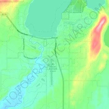
McCall topographic map

Click on the map to display elevation.

McCall

McCall is located at 44°54′39″N 116°6′11″W / 44.91083°N 116.10306°W / 44.91083; -116.10306 (44.910906, -116.103087),[7] at an elevation of 5,013 feet (1,528 m) above sea level.

Wikipedia (CC-BY-SA 3.0)

About this map

Name: McCall topographic map, elevation, terrain.

Location: McCall, Valley County, Idaho, 83638, United States (44.86605 -116.16411 44.93408 -116.06501)

Average elevation: 1,546 m

Minimum elevation: 1,491 m

Maximum elevation: 1,703 m

Other topographic maps

Click on a map to view its topography, its elevation and its terrain.

Diamond Point

United States > Idaho > Valley County

Average elevation: 2,067 m

Warm Lake

United States > Idaho > Valley County > Warm Lake

Average elevation: 1,641 m

Chief

United States > Idaho > Valley County

Average elevation: 2,249 m

Moore Point

United States > Idaho > Valley County

Average elevation: 2,343 m

Blackmare Lake

United States > Idaho > Valley County

Average elevation: 2,298 m

Gear up for your next adventure:

🧥Thermal Emergency Blankets - Compact Mylar blankets to prevent hypothermia if stranded overnight
🐍Snake Gaiters - Protection against snake bites
📦Crushproof Equipment Cases - Safe transport for sensitive surveying and mapping instruments
🦯Adjustable Trekking Poles - Reduce impact on knees when descending steep topographic ridges
🧊Insulated Stainless Steel Flasks - Keep water cold for 24 hours in the heat or coffee hot in the cold

As an Amazon Associate, this site earns from qualifying purchases at no extra cost to you.