
Province of Yungay topographic map
Interactive map
Click on the map to display elevation.
About this map
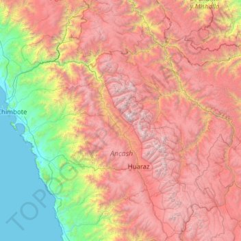
Name: Province of Yungay topographic map, elevation, terrain.
Location: Province of Yungay, Ancash, Peru (-10.15132 -78.68121 -8.15132 -76.68121)
Average elevation: 2,668 m
Minimum elevation: 0 m
Maximum elevation: 6,632 m
Other topographic maps
Click on a map to view its topography, its elevation and its terrain.
Artesonraju
Peru > Ancash > Santa Cruz
Artesonraju, Santa Cruz, Province of Huaylas, Ancash, Peru
Average elevation: 5,138 m
Ruina Yayno
Ruina Yayno, AN-613, Lucma, Mariscal Luzuriaga, Ancash, Peru
Average elevation: 3,887 m
Province of Huari
Province of Huari, Huachis, Huari, Ancash, Peru
Average elevation: 3,183 m
Province of Carhuaz
Province of Carhuaz, Marcará, Carhuaz, Ancash, Peru
Average elevation: 3,217 m
Alpamayo
Peru > Ancash > Santa Cruz
Alpamayo, Santa Cruz, Huaylas, Ancash, Peru
Average elevation: 5,210 m