
Chaitén topographic map
Interactive map
Click on the map to display elevation.
About this map
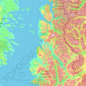
Name: Chaitén topographic map, elevation, terrain.
Average elevation: 485 m
Minimum elevation: 0 m
Maximum elevation: 2,449 m
Östlich von Chaitén liegt der Vulkan Michinmahuida mit 2404 m Höhe. Südöstlich der Stadt liegen die Thermalquellen Termas El Amarillo.
Other topographic maps
Click on a map to view its topography, its elevation and its terrain.
Futaleufú
Chile > Región de Los Lagos > Provincia de Palena > Futaleufú
Futaleufú, Provincia de Palena, Región de Los Lagos, 5870000, Chile
Average elevation: 989 m