
Bavarian Forest National Park topographic map
Interactive map
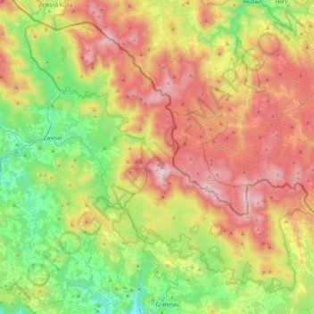
Click on the map to display elevation.
About this map
Name: Bavarian Forest National Park topographic map, elevation, terrain.
Average elevation: 870 m
Minimum elevation: 453 m
Maximum elevation: 1,435 m
Especially protected are the Norway spruce–dominated highland forests, mixed mountain forests of European silver fir, European beech and spruce trees and water meadow spruce woods in the valleys. Although a few remnants of ancient forest remain, the National Park area is still heavily influenced by the former forestry industry. Since nature is now left to take its course again, there is no human intervention when there are catastrophic events such as large scale bark beetle infestation. This resulted in the death of a portion of the high elevation forests in the 1990s and triggered controversial discussions amongst the residents of the National Park, which highlighted differing attitudes to the wilderness. As the result of a compromise, bark beetle is now fought in the buffer area.
Other topographic maps
Click on a map to view its topography, its elevation and its terrain.
Großer Arber
Germany > Bavaria > Landkreis Regen > Bayerisch Eisenstein
Großer Arber, Bayerisch Eisenstein, Landkreis Regen, Bavaria, Germany
Average elevation: 1,141 m
Bayerisch Eisenstein
Germany > Bavaria > Landkreis Regen
Bayerisch Eisenstein, Landkreis Regen, Bavaria, 94252, Germany
Average elevation: 919 m