
Folgosinho topographic map
Interactive map
Click on the map to display elevation.
About this map
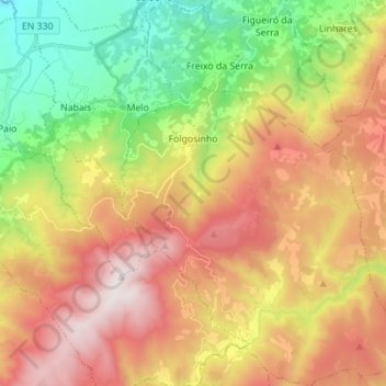
Name: Folgosinho topographic map, elevation, terrain.
Location: Folgosinho, Gouveia, Guarda, 6290-081, Portugal (40.44278 -7.53912 40.54850 -7.43426)
Average elevation: 947 m
Minimum elevation: 360 m
Maximum elevation: 1,594 m
Foi vila e sede de concelho entre 1187 e 1836. Era constituído apenas pela freguesia da sede. Localiza-se na vertente Noroeste da Serra da Estrela, atingindo os 930 metros de altitude.
Other topographic maps
Click on a map to view its topography, its elevation and its terrain.
Nespereira
Nespereira, Gouveia, Guarda, 6290-205, Portugal
Average elevation: 504 m
São Julião
São Julião, Gouveia, Guarda, 6290-320, Portugal
Average elevation: 704 m