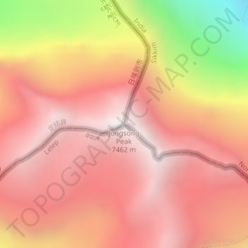
Jongsong Peak topographic map
Interactive map
Click on the map to display elevation.
About this map
Name: Jongsong Peak topographic map, elevation, terrain.
Average elevation: 6,947 m
Minimum elevation: 5,885 m
Maximum elevation: 7,457 m

Click on the map to display elevation.
Name: Jongsong Peak topographic map, elevation, terrain.
Average elevation: 6,947 m
Minimum elevation: 5,885 m
Maximum elevation: 7,457 m