
Freiburg Alps topographic map
Interactive map
Click on the map to display elevation.
About this map
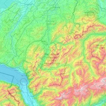
Name: Freiburg Alps topographic map, elevation, terrain.
Location: Freiburg Alps, Fribourg, Switzerland (46.31679 6.80875 46.79103 7.65458)
Average elevation: 1,174 m
Minimum elevation: 367 m
Maximum elevation: 3,220 m
Other topographic maps
Click on a map to view its topography, its elevation and its terrain.
Bulle
Switzerland > Fribourg > Gruyère District > Bulle
Bulle, Gruyère District, Fribourg, Switzerland
Average elevation: 834 m
La Tour-de-Trême
Switzerland > Fribourg > Bulle > La Tour-de-Trême
La Tour-de-Trême, Bulle, Gruyère District, Fribourg, 1635, Switzerland
Average elevation: 758 m
Giffers
Switzerland > Fribourg > Giffers
Giffers, Sensebezirk, Fribourg, 1735, Switzerland
Average elevation: 775 m
La Sarine
Switzerland > Fribourg > Bas-Intyamon
La Sarine, Bas-Intyamon, Gruyère District, Fribourg, 1666, Switzerland
Average elevation: 897 m
Gibloux
Switzerland > Fribourg > Gibloux
Gibloux, Sarine District, Fribourg, Switzerland
Average elevation: 761 m