
Bussana topographic map
Interactive map
Click on the map to display elevation.
About this map
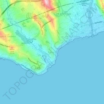
Name: Bussana topographic map, elevation, terrain.
Location: Bussana, Sanremo, Imperia, Ligurie, 18011, Italie (43.80493 7.81829 43.84493 7.85829)
Average elevation: 41 m
Minimum elevation: -2 m
Maximum elevation: 288 m
Other topographic maps
Click on a map to view its topography, its elevation and its terrain.