

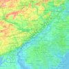
Bucks County topographic map
Click on the map to display elevation.
Bucks County
According to the Trewartha climate classification system, the Piedmont (United States) section of Bucks County, which is located roughly northwest of U.S. Route 1, has a Temperate Continental Climate with hot and slightly humid summers, cold winters and year-around precipitation (Dcao). Dcao climates are characterized by at least one month having an average mean temperature ≤ 32.0 °F (0 °C), four to seven months with an average mean temperature ≥ 50.0 °F (10 °C), at least one month with an average mean temperature ≥ 72.0 °F (22 °C) and no significant precipitation difference between seasons. According to the Köppen climate classification system, the climate is a hot-summer, wet all year, humid continental climate (Dfa). During the summer months in the Piedmont, episodes of extreme heat and humidity can occur with heat index values > 102 °F (39 °C). The average wettest month is July which corresponds with the annual peak in thunderstorm activity. During the winter months, episodes of extreme cold and wind can occur with wind chill values < −16 °F (−27 °C). The plant hardiness zone at Haycock Mountain, elevation 968 ft (295 m), is 6b with an average annual extreme minimum air temperature of −4.6 °F (−20 °C). The average seasonal (Nov-Apr) snowfall total is between 26 and 36 inches (66 and 91 cm) depending on elevation and distance from the Atlantic Ocean. The average snowiest month is February which correlates with the annual peak in nor'easter activity. Some areas of the Piedmont farther south and along the river below New Hope are in hardiness zone 7a, as is the Atlantic Coastal Plain region of Bucks.
About this map
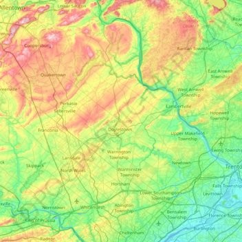
Name: Bucks County topographic map, elevation, terrain.
Location: Bucks County, Pennsylvania, United States (40.04980 -75.48393 40.60872 -74.72111)
Average elevation: 98 m
Minimum elevation: -2 m
Maximum elevation: 312 m
Other topographic maps
Click on a map to view its topography, its elevation and its terrain.

Lafayette Hill
United States > Pennsylvania > Montgomery County > Whitemarsh Township
Average elevation: 59 m


Albrightsville
United States > Pennsylvania > Carbon County > Kidder Township
Average elevation: 498 m

Sterling
United States > Pennsylvania > Clearfield County > Woodward Township
Average elevation: 491 m

Spaces Corners
United States > Pennsylvania > Armstrong County > Rayburn Township
Average elevation: 360 m
East Texas
United States > Pennsylvania > Lehigh County > Lower Macungie Township
Average elevation: 126 m



West Derry
United States > Pennsylvania > Westmoreland County > Derry Township
Average elevation: 408 m

Nottingham
United States > Pennsylvania > Chester County > West Nottingham Township
Average elevation: 145 m

Hooverville
United States > Pennsylvania > Westmoreland County > Saint Clair Township
Average elevation: 385 m
Cowden
United States > Pennsylvania > Washington County > Cecil Township > Cecil
Average elevation: 346 m
West Pittsburg
United States > Pennsylvania > Lawrence County > Taylor Township
Average elevation: 279 m

Strawberry Mansion
United States > Pennsylvania > Philadelphia County > Philadelphia
Average elevation: 31 m


Acme
United States > Pennsylvania > Westmoreland County > Mount Pleasant Township
Average elevation: 585 m



Elkins Park Gardens
United States > Pennsylvania > Montgomery County > Cheltenham Township > Cheltenham
Average elevation: 70 m




Lindberg Heights
United States > Pennsylvania > Montgomery County > Limerick Township > Limerick
Average elevation: 88 m
Strabane
United States > Pennsylvania > Washington County > North Strabane Township
Average elevation: 329 m

Marshalls Creek
United States > Pennsylvania > Monroe County > Smithfield Township
Average elevation: 186 m


Sturgeon
United States > Pennsylvania > Allegheny County > North Fayette Township
Average elevation: 334 m
Cross Fork
United States > Pennsylvania > Potter County > Stewardson Township
Average elevation: 467 m

Wilson Mills
United States > Pennsylvania > Venango County > Jackson Township
Average elevation: 453 m

East Kensington
United States > Pennsylvania > Westmoreland County > New Kensington
Average elevation: 275 m
Dingmans Ferry
United States > Pennsylvania > Pike County > Delaware Township
Average elevation: 192 m

White Church
United States > Pennsylvania > Westmoreland County > North Huntingdon Township
Average elevation: 331 m
Mount Nebo Park
United States > Pennsylvania > Monroe County > East Stroudsburg > Twin Falls
Average elevation: 185 m

Pricetown
United States > Pennsylvania > Berks County > Ruscombmanor Township
Average elevation: 239 m
Cornwells Heights
United States > Pennsylvania > Bucks County > Bensalem Township
Average elevation: 16 m
Keown Station
United States > Pennsylvania > Allegheny County > Ross Township
Average elevation: 344 m


Stony Creek Mills
United States > Pennsylvania > Berks County > Lower Alsace Township > Pennside
Average elevation: 192 m

Riddlesburg
United States > Pennsylvania > Bedford County > Broad Top Township
Average elevation: 373 m

New Enterprise
United States > Pennsylvania > Bedford County > South Woodbury Township
Average elevation: 397 m
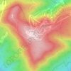
Blue Knob
United States > Pennsylvania > Bedford County > Pavia Township
Blue Knob (elevation 3,146 feet (959 m)) is a summit in the eastern United States with a broad dome that is the northernmost 3,000-footer in the Allegheny Mountains. It is the highest point in Bedford County, Pennsylvania.
Average elevation: 792 m

Sinnemahoning
United States > Pennsylvania > Cameron County > Gibson Township
Average elevation: 406 m
Saint Benedict
United States > Pennsylvania > Cambria County > West Carroll Township
Average elevation: 582 m
English Center
United States > Pennsylvania > Lycoming County > Pine Township
Average elevation: 444 m

Tyrrel Farm Corners
United States > Pennsylvania > Venango County > Allegheny Township
Average elevation: 478 m

Rockville
United States > Pennsylvania > Dauphin County > Susquehanna Township
Average elevation: 141 m
Fort Hunter
United States > Pennsylvania > Dauphin County > Middle Paxton Township
Average elevation: 149 m

Green Village
United States > Pennsylvania > Franklin County > Greene Township
Average elevation: 207 m
Normalville
United States > Pennsylvania > Fayette County > Springfield Township
Average elevation: 486 m
Arnold City
United States > Pennsylvania > Fayette County > Washington Township
Average elevation: 303 m
Three Tuns
United States > Pennsylvania > Montgomery County > Upper Dublin Township > Maple Glen
Average elevation: 101 m
Hidden Valley
United States > Pennsylvania > Montgomery County > Upper Merion Township
Average elevation: 47 m
Worcester
United States > Pennsylvania > Montgomery County > Worcester Township
Average elevation: 93 m
Strafford
United States > Pennsylvania > Chester County > Tredyffrin Township
Average elevation: 133 m
Pennsylvania Furnace
United States > Pennsylvania > Huntingdon County > Franklin Township
Average elevation: 363 m
Dilltown
United States > Pennsylvania > Indiana County > East Wheatfield Township
Average elevation: 474 m
Robinson
United States > Pennsylvania > Indiana County > West Wheatfield Township
Average elevation: 397 m
Hazelton Mills
United States > Pennsylvania > McKean County > Bradford Township
Average elevation: 598 m
Fogelsville
United States > Pennsylvania > Lehigh County > Upper Macungie Township
Average elevation: 155 m