
Saint-Claude topographic map
Interactive map
Click on the map to display elevation.
About this map
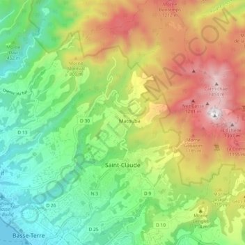
Name: Saint-Claude topographic map, elevation, terrain.
Location: Saint-Claude, Basse-Terre, Guadeloupe, 97120, France (15.99660 -61.73165 16.08461 -61.66046)
Average elevation: 579 m
Minimum elevation: 0 m
Maximum elevation: 1,449 m
Other topographic maps
Click on a map to view its topography, its elevation and its terrain.