
Thank you for supporting this site ❤️
Make a donation
Make a donation
Gear up for your next adventure:
🧭Military Style Lensatic Compass - Durable sighting compasses for advanced land navigation and surveying
As an Amazon Associate, this site earns from qualifying purchases at no extra cost to you.
Pegnitz topographic map
Click on the map to display elevation.
Thank you for supporting this site ❤️
Make a donation
Make a donation
Gear up for your next adventure:
As an Amazon Associate, this site earns from qualifying purchases at no extra cost to you.
About this map
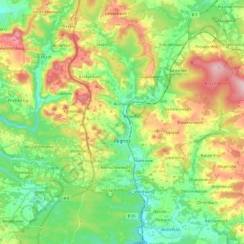
Name: Pegnitz topographic map, elevation, terrain.
Location: Pegnitz, Landkreis Bayreuth, Bavaria, 91257, Germany (49.69628 11.42391 49.83802 11.63376)
Average elevation: 485 m
Minimum elevation: 392 m
Maximum elevation: 637 m
Thank you for supporting this site ❤️
Make a donation
Make a donation
Gear up for your next adventure:
As an Amazon Associate, this site earns from qualifying purchases at no extra cost to you.