
Make a donation
Gear up for your next adventure:
As an Amazon Associate, this site earns from qualifying purchases at no extra cost to you.
Pendleton topographic map
Click on the map to display elevation.
Make a donation
Gear up for your next adventure:
As an Amazon Associate, this site earns from qualifying purchases at no extra cost to you.
About this map
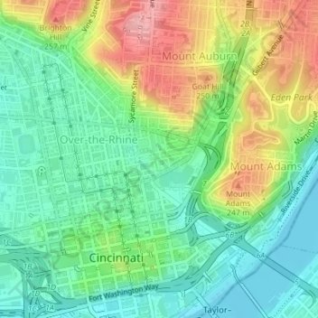
Name: Pendleton topographic map, elevation, terrain.
Location: Pendleton, Cincinnati, Hamilton County, Ohio, United States (39.10713 -84.51087 39.11255 -84.50142)
Average elevation: 188 m
Minimum elevation: 140 m
Maximum elevation: 271 m
Make a donation
Gear up for your next adventure:
As an Amazon Associate, this site earns from qualifying purchases at no extra cost to you.
Other topographic maps
Click on a map to view its topography, its elevation and its terrain.
Make a donation
Gear up for your next adventure:
As an Amazon Associate, this site earns from qualifying purchases at no extra cost to you.
Norwood Heights
United States > Ohio > Hamilton County > Cincinnati > Norwood Heights
Average elevation: 207 m
Make a donation
Gear up for your next adventure:
As an Amazon Associate, this site earns from qualifying purchases at no extra cost to you.