
Make a donation
Gear up for your next adventure:
As an Amazon Associate, this site earns from qualifying purchases at no extra cost to you.
Woodberry topographic map
Click on the map to display elevation.
Make a donation
Gear up for your next adventure:
As an Amazon Associate, this site earns from qualifying purchases at no extra cost to you.
Woodberry
Woodberry also houses the facilities for four of Baltimore's commercial television stations, and because of its altitude, it also is the site of two large broadcasting masts. This area, once known as Malden Hill, is also known as Television Hill (or simply TV Hill). The first television station and transmission tower were completed in 1948.
Make a donation
Gear up for your next adventure:
As an Amazon Associate, this site earns from qualifying purchases at no extra cost to you.
About this map
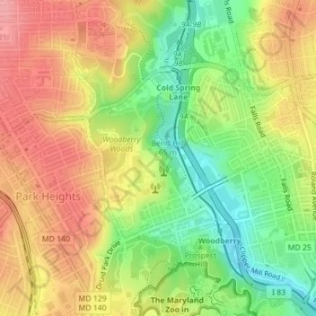
Name: Woodberry topographic map, elevation, terrain.
Location: Woodberry, Park Heights, Baltimore, Maryland, United States (39.32956 -76.65820 39.34524 -76.64207)
Average elevation: 94 m
Minimum elevation: 40 m
Maximum elevation: 141 m
Make a donation
Gear up for your next adventure:
As an Amazon Associate, this site earns from qualifying purchases at no extra cost to you.
Other topographic maps
Click on a map to view its topography, its elevation and its terrain.
Baltimore
United States > Maryland > Baltimore
Baltimore is in north-central Maryland on the Patapsco River close to where it empties into the Chesapeake Bay. The city is also located on the fall line between the Piedmont Plateau and the Atlantic coastal plain, which divides Baltimore into "lower city" and "upper city". The city's elevation ranges from sea…
Average elevation: 65 m
Station North Arts and Entertainment District
United States > Maryland > Baltimore
Average elevation: 40 m
Make a donation
Gear up for your next adventure:
As an Amazon Associate, this site earns from qualifying purchases at no extra cost to you.