
Lockerbie topographic map
Interactive map
Click on the map to display elevation.
About this map
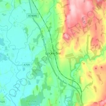
Name: Lockerbie topographic map, elevation, terrain.
Average elevation: 96 m
Minimum elevation: 35 m
Maximum elevation: 234 m
Other topographic maps
Click on a map to view its topography, its elevation and its terrain.
Sanquhar
United Kingdom > Scotland > Dumfries and Galloway
Sanquhar, Dumfries and Galloway, Scotland, DG4 6DJ, United Kingdom
Average elevation: 243 m
Gillesbie
United Kingdom > Scotland > Dumfries and Galloway > Boreland
Gillesbie, Boreland, Dumfries and Galloway, Scotland, DG11 2LF, United Kingdom
Average elevation: 195 m
Holywood
United Kingdom > Scotland > Dumfries and Galloway
Holywood, Dumfries and Galloway, Scotland, DG2 0RE, United Kingdom
Average elevation: 26 m
Ley Hill
United Kingdom > Scotland > Dumfries and Galloway
Ley Hill, Dumfries and Galloway, Scotland, DG11 3HG, United Kingdom
Average elevation: 214 m
Cairnryan
United Kingdom > Scotland > Dumfries and Galloway > Cairnryan
Cairnryan, Dumfries and Galloway, Scotland, DG9 8RB, United Kingdom
Average elevation: 64 m
Drummore
United Kingdom > Scotland > Dumfries and Galloway
Drummore, Dumfries and Galloway, Scotland, DG9 9PY, United Kingdom
Average elevation: 36 m