
Make a donation
Gear up for your next adventure:
As an Amazon Associate, this site earns from qualifying purchases at no extra cost to you.
Harwich topographic map
Click on the map to display elevation.
Make a donation
Gear up for your next adventure:
As an Amazon Associate, this site earns from qualifying purchases at no extra cost to you.
About this map
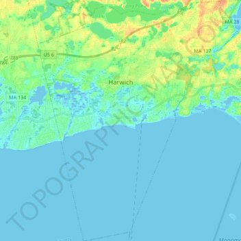
Name: Harwich topographic map, elevation, terrain.
Location: Harwich, Barnstable County, Massachusetts, United States (41.60332 -70.13385 41.72894 -69.98038)
Average elevation: 7 m
Minimum elevation: -4 m
Maximum elevation: 34 m
Make a donation
Gear up for your next adventure:
As an Amazon Associate, this site earns from qualifying purchases at no extra cost to you.
Other topographic maps
Click on a map to view its topography, its elevation and its terrain.
Shank Painter Pond
United States > Massachusetts > Barnstable County > Provincetown
Average elevation: 4 m
East Brewster
United States > Massachusetts > Barnstable County > Brewster > East Brewster
Average elevation: 16 m
Harwich Port
United States > Massachusetts > Barnstable County > Harwich > Harwich Port
Average elevation: 3 m
Mayflower Heights
United States > Massachusetts > Barnstable County > Provincetown
Average elevation: 2 m
Make a donation
Gear up for your next adventure:
As an Amazon Associate, this site earns from qualifying purchases at no extra cost to you.