Geolocate

Ashill topographic map

Click on the map to display elevation.

About this map

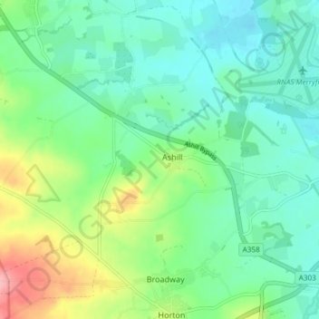
Name: Ashill topographic map, elevation, terrain.

Location: Ashill, Somerset, England, United Kingdom (50.93588 -3.00361 50.96733 -2.92959)

Average elevation: 54 m

Minimum elevation: 21 m

Maximum elevation: 136 m

Gear up for your next adventure:

🍶Collapsible Water Bottles - Save space in your pack as you consume your water supply
🎒Daypacks - Compact backpacks for short hikes
🥾Hiking Gaiters - Leg protection for trails
🔥Ferrocerium Rod Fire Starters - Reliable fire lighting in wet or windy conditions without matches
🧯Animal Deterrent Spray - Safety spray for wildlife

As an Amazon Associate, this site earns from qualifying purchases at no extra cost to you.