
Melilis Island topographic map
Interactive map
Click on the map to display elevation.
About this map
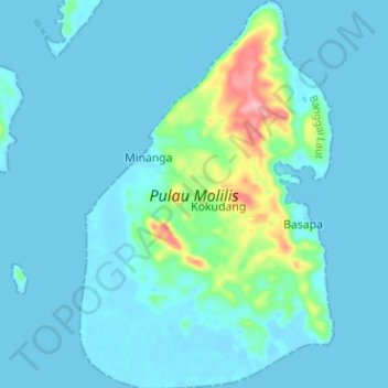
Name: Melilis Island topographic map, elevation, terrain.
Location: Melilis Island, Central Sulawesi, Indonesia (-1.96218 123.69784 -1.89873 123.73939)
Average elevation: 17 m
Minimum elevation: -2 m
Maximum elevation: 138 m
Other topographic maps
Click on a map to view its topography, its elevation and its terrain.
Pamona
Pamona, Poso Regency, Central Sulawesi, Sulawesi, Indonesia
Average elevation: 786 m
Pete
Indonesia > Central Sulawesi > Tolitoli
Pete, Tolitoli, Central Sulawesi, Indonesia
Average elevation: 191 m
Poo
Indonesia > Central Sulawesi > Morowali > Poo
Poo, Morowali, Central Sulawesi, Indonesia
Average elevation: 392 m
Pepe
Indonesia > Central Sulawesi > Tolitoli > Pepe
Pepe, Tolitoli, Central Sulawesi, Indonesia
Average elevation: 74 m
Poso
Indonesia > Central Sulawesi > Poso
Poso, Poso Regency, Central Sulawesi, 94619, Indonesia
Average elevation: 33 m
Beau
Indonesia > Central Sulawesi > Parigi Moutong Regency
Beau, Parigi Moutong Regency, Central Sulawesi, Indonesia
Average elevation: 711 m
Huidu Tentolomatinan
Huidu Tentolomatinan, Buol, Central Sulawesi, Indonesia
Average elevation: 1,846 m
Poso
Indonesia > Central Sulawesi > Poso
Poso, Poso Regency, Central Sulawesi, 94619, Indonesia
Average elevation: 43 m
Lore Lindu National Park
Indonesia > Central Sulawesi > Dodolo
Lore Lindu National Park, Dodolo, Poso Regency, Central Sulawesi, Indonesia
Average elevation: 1,124 m
Lombok
Indonesia > Central Sulawesi > Lombok
Lombok, Parigi Moutong Regency, Central Sulawesi, Indonesia
Average elevation: 514 m
Parigi Moutong Regency
Parigi Moutong Regency, Central Sulawesi, 94471, Indonesia
Average elevation: 133 m
Fuyul Sojol
Fuyul Sojol, Parigi Moutong Regency, Central Sulawesi, Indonesia
Average elevation: 2,422 m
Peleng Island
Peleng Island, Banggai Islands Regency, Central Sulawesi, Indonesia
Average elevation: 117 m
Poso
Poso, Poso Regency, Central Sulawesi, 94619, Indonesia
Average elevation: 631 m
Sidoarjo
Indonesia > Central Sulawesi > Sidoarjo
Sidoarjo, Kecamatan Baolan, Tolitoli, Central Sulawesi, 94511, Indonesia
Average elevation: 38 m