
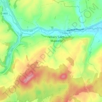
Villars-Saint-Marcellin topographic map
Interactive map
Click on the map to display elevation.
About this map
Name: Villars-Saint-Marcellin topographic map, elevation, terrain.
Average elevation: 297 m
Minimum elevation: 246 m
Maximum elevation: 365 m
Other topographic maps
Click on a map to view its topography, its elevation and its terrain.
Fontaine Salée
France > Grand Est > Haute-Marne > Bourbonne-les-Bains
Fontaine Salée, Bourbonne-les-Bains, Langres, Haute-Marne, Grand Est, France métropolitaine, 52400, France
Average elevation: 288 m