Geolocate

Clondalkin topographic map

Click on the map to display elevation.

About this map

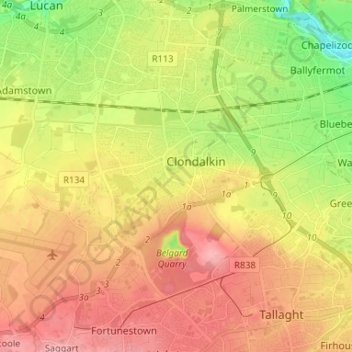
Name: Clondalkin topographic map, elevation, terrain.

Location: Clondalkin, South Dublin, County Dublin, Leinster, Ireland (53.28849 -6.47867 53.34862 -6.34727)

Average elevation: 73 m

Minimum elevation: 4 m

Maximum elevation: 135 m

Other topographic maps

Click on a map to view its topography, its elevation and its terrain.

Corkagh Park

Ireland > County Dublin > Clondalkin

Average elevation: 80 m

Ballymount

Ireland > County Dublin > Clondalkin

Average elevation: 68 m

Gear up for your next adventure:

🚁Camera Drones with GPS - Capture aerial views of the landscape to compare with topo maps
🪫Rechargeable Headlamps - USB rechargeable headlamps
🧼Clip-on Hand Sanitizer - Maintain hygiene when water for washing is scarce
🚴Bike GPS - GPS devices for cycling
🔪Multitools - Compact tools for outdoor use

As an Amazon Associate, this site earns from qualifying purchases at no extra cost to you.