
Pittsfield topographic map
Interactive map
Click on the map to display elevation.
About this map
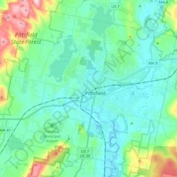
Name: Pittsfield topographic map, elevation, terrain.
Location: Pittsfield, Berkshire County, Massachusetts, United States (42.39813 -73.33891 42.50461 -73.18220)
Average elevation: 369 m
Minimum elevation: 286 m
Maximum elevation: 697 m
Pittsfield has a humid continental climate (Dfb). Winters are harsh due the city's high elevation at 1,039 ft (317 m), with an average annual snowfall of 75.9 inches (1,930 mm) and temperatures dipping to 0 °F (−18 °C) or colder 13 times per year. Summers, however, are typically warm and pleasant, with temperatures reaching 90 °F (32 °C) just six times per year. The record high and record low are 101 °F (38 °C) and −26 °F (−32 °C), recorded on July 23, 1926, and February 15, 1943, respectively. Over the course of a year, there are 173 days with measurable precipitation.
Other topographic maps
Click on a map to view its topography, its elevation and its terrain.
Meadowvale
United States > Massachusetts > Berkshire County > Williamstown
Meadowvale, Williamstown, Berkshire County, Massachusetts, 01267, United States
Average elevation: 248 m
Becket
United States > Massachusetts > Berkshire County
Becket, Berkshire County, Massachusetts, 01238, United States
Average elevation: 480 m
Williamstown
United States > Massachusetts > Berkshire County > Williamstown
Williamstown, Berkshire County, Massachusetts, 01267, United States
Average elevation: 433 m