
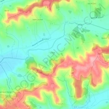
Saint-Laurent-Lolmie topographic map
Interactive map
Click on the map to display elevation.
About this map
Name: Saint-Laurent-Lolmie topographic map, elevation, terrain.
Average elevation: 180 m
Minimum elevation: 124 m
Maximum elevation: 266 m
Other topographic maps
Click on a map to view its topography, its elevation and its terrain.
Saint-Cyprien
France > Occitanie > Lot > Lendou-en-Quercy
Saint-Cyprien, Lendou-en-Quercy, Cahors, Lot, Occitanie, France métropolitaine, 46800, France
Average elevation: 204 m
Lascabanes
France > Occitanie > Lot > Lendou-en-Quercy
Lascabanes, Lendou-en-Quercy, Cahors, Lot, Occitanie, France métropolitaine, 46800, France
Average elevation: 229 m
Lolmie
France > Occitanie > Lot > Lendou-en-Quercy
Lolmie, Saint-Laurent-Lolmie, Lendou-en-Quercy, Cahors, Lot, Occitanie, France métropolitaine, 46800, France
Average elevation: 180 m
Saint-Laurent
France > Occitanie > Lot > Lendou-en-Quercy
Saint-Laurent, Saint-Laurent-Lolmie, Lendou-en-Quercy, Cahors, Lot, Occitanie, France métropolitaine, 46800, France
Average elevation: 184 m