Geolocate

Milton topographic map

Click on the map to display elevation.

About this map

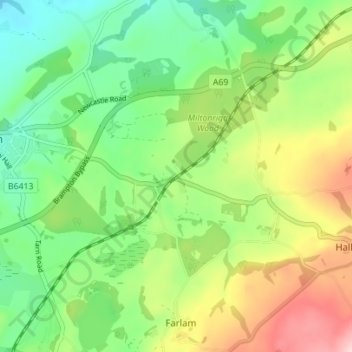
Name: Milton topographic map, elevation, terrain.

Location: Milton, Brampton, Cumberland, England, CA8 1HX, United Kingdom (54.91792 -2.71493 54.95792 -2.67493)

Average elevation: 139 m

Minimum elevation: 57 m

Maximum elevation: 276 m

Other topographic maps

Click on a map to view its topography, its elevation and its terrain.

Naworth Castle

United Kingdom > England > Cumberland > Brampton > Naworth

Average elevation: 100 m

Gear up for your next adventure:

🕶️Polarized Outdoor Sunglasses - Reduce glare from rocks and water for better visual navigation
🧦Hiking Socks - Comfortable socks for long hikes
🛰️Handheld GPS Units - Rugged GPS devices for tracking coordinates and elevation in the Australian bush
🔦Headlamps - Hands-free lighting for hiking
🧊Insulated Stainless Steel Flasks - Keep water cold for 24 hours in the heat or coffee hot in the cold

As an Amazon Associate, this site earns from qualifying purchases at no extra cost to you.