
Sept-Îles topographic map
Interactive map
Click on the map to display elevation.
About this map
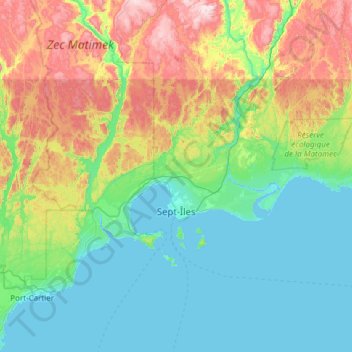
Name: Sept-Îles topographic map, elevation, terrain.
Location: Sept-Îles, Sept-Rivières, Côte-Nord, Québec, Canada (50.07828 -66.72530 50.49399 -65.51313)
Average elevation: 189 m
Minimum elevation: -4 m
Maximum elevation: 802 m
Other topographic maps
Click on a map to view its topography, its elevation and its terrain.
Mont de la Louve Nuit
Canada > Québec > Sept-Rivières > Lac-Walker
Mont de la Louve Nuit, Lac-Walker, Sept-Rivières, Côte-Nord, Québec, Canada
Average elevation: 506 m
Lac Colbert
Canada > Québec > Sept-Rivières > Port-Cartier
Lac Colbert, Port-Cartier, Sept-Rivières, Côte-Nord, Québec, Canada
Average elevation: 284 m
Rivière Pentecôte
Canada > Québec > Sept-Rivières > Port-Cartier
Rivière Pentecôte, Port-Cartier, Sept-Rivières, Côte-Nord, Québec, Canada
Average elevation: 120 m