
La Billardais des Alleux topographic map
Interactive map
Click on the map to display elevation.
About this map
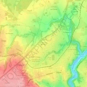
Name: La Billardais des Alleux topographic map, elevation, terrain.
Average elevation: 73 m
Minimum elevation: 5 m
Maximum elevation: 131 m
Other topographic maps
Click on a map to view its topography, its elevation and its terrain.
La Menardais
France > Bretagne > Côtes-d'Armor > Taden
La Menardais, Taden, Dinan, Côtes-d'Armor, Bretagne, France métropolitaine, 22100, France
Average elevation: 55 m