Geolocate

Gempol topographic map

Click on the map to display elevation.

About this map

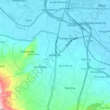
Name: Gempol topographic map, elevation, terrain.

Location: Gempol, Pasuruan, East Java, Java, 60135, Indonesia (-7.61944 112.65042 -7.53944 112.73042)

Average elevation: 47 m

Minimum elevation: -2 m

Maximum elevation: 381 m

Gear up for your next adventure:

🌧️Rain Jackets - Waterproof jackets for hiking
🎒Tactical Waist Packs - Quick access to your compass, phone, and snacks while walking
🛰️Handheld GPS Units - Rugged GPS devices for tracking coordinates and elevation in the Australian bush
Altimeter Watches - Watches with altitude tracking
🩹First Aid Kits - Emergency kits for hiking

As an Amazon Associate, this site earns from qualifying purchases at no extra cost to you.