
Make a donation
Gear up for your next adventure:
As an Amazon Associate, this site earns from qualifying purchases at no extra cost to you.
Playas topographic map
Click on the map to display elevation.
Make a donation
Gear up for your next adventure:
As an Amazon Associate, this site earns from qualifying purchases at no extra cost to you.
About this map
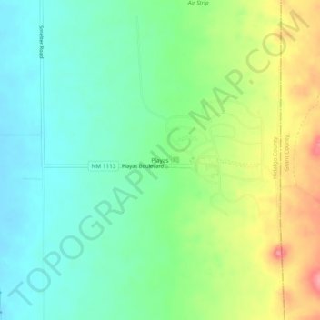
Name: Playas topographic map, elevation, terrain.
Location: Playas, Hidalgo County, New Mexico, United States (31.89515 -108.56238 31.93515 -108.52238)
Average elevation: 1,360 m
Minimum elevation: 1,324 m
Maximum elevation: 1,427 m
Make a donation
Gear up for your next adventure:
As an Amazon Associate, this site earns from qualifying purchases at no extra cost to you.
Other topographic maps
Click on a map to view its topography, its elevation and its terrain.
Lordsburg
United States > New Mexico > Hidalgo County
Typical for the more southerly and lower elevations of the Intermountain West, summers are extremely hot during the daytime, with maxima above 90 °F or 32.2 °C for over four months on an average of 122 afternoons during a full year. 100 °F or 37.8 °C is exceeded on average during 30 afternoons each year,…
Average elevation: 1,309 m