
La Prise Tarot topographic map
Interactive map
Click on the map to display elevation.
About this map
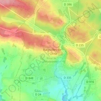
Name: La Prise Tarot topographic map, elevation, terrain.
Average elevation: 194 m
Minimum elevation: 143 m
Maximum elevation: 254 m
Other topographic maps
Click on a map to view its topography, its elevation and its terrain.
Les Milles Mottes
France > Normandie > Orne > Bagnoles-de-l'Orne-Normandie > Bagnoles-de-l'Orne
Les Milles Mottes, Bagnoles-de-l'Orne, Bagnoles-de-l'Orne-Normandie, Alençon, Orne, Normandie, France métropolitaine, 61140, France
Average elevation: 191 m
Loup Pendu
France > Normandie > Orne > Bagnoles-de-l'Orne-Normandie > Bagnoles-de-l'Orne
Loup Pendu, Bagnoles-de-l'Orne, Bagnoles-de-l'Orne-Normandie, Alençon, Orne, Normandie, France métropolitaine, 61140, France
Average elevation: 190 m