Geolocate

Bisignano topographic map

Click on the map to display elevation.

About this map
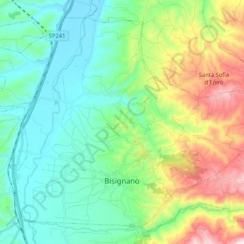
Name: Bisignano topographic map, elevation, terrain.

Location: Bisignano, Cosenza, Calabria, 87043, Italy (39.47901 16.21139 39.57486 16.35606)

Average elevation: 256 m

Minimum elevation: 57 m

Maximum elevation: 770 m

Other topographic maps

Click on a map to view its topography, its elevation and its terrain.

Ceci

Italy > Calabria > Cosenza > Aprigliano

Average elevation: 1,364 m

Sila National Park

Italy > Calabria > Cosenza

Average elevation: 894 m

Sibari

Italy > Calabria > Cosenza > Cassano all'Ionio > Sibari

Average elevation: 7 m

Corigliano Calabro

Italy > Calabria > Cosenza

Average elevation: 231 m

Quattromiglia

Italy > Calabria > Cosenza > Rende

Average elevation: 193 m

Trenta

Italy > Calabria > Cosenza

Trenta is a town high in the Crati river Valley. The town's ancient name, Triginta, derives from the Latin number triginta or thirty. Trenta was founded by Cosentine refugees in the 10th century AD, in the era of Saracen occupations of the nearby capital, Magli, which eventually became one of the…

Average elevation: 560 m

Lago Tarsia

Italy > Calabria > Cosenza > Tarsia

Average elevation: 138 m

Gear up for your next adventure:

⛺Lightweight Tents - Compact tents for backpacking
📕Hiking Guide Books - Guides for hiking trails
📟Satellite Messengers - Two-way satellite communication to stay in touch beyond the cellular grid
🧺Waterproof Dry Sacks - Organize your pack and keep electronics safe from rain and river crossings
🔌Fast Charging Adapters - Quickly top up all your gear before heading back into the field

As an Amazon Associate, this site earns from qualifying purchases at no extra cost to you.