
Farellones topographic map
Interactive map
Click on the map to display elevation.
About this map
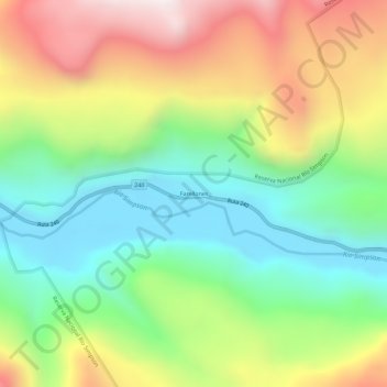
Name: Farellones topographic map, elevation, terrain.
Average elevation: 544 m
Minimum elevation: 115 m
Maximum elevation: 1,177 m
Other topographic maps
Click on a map to view its topography, its elevation and its terrain.
Isla Latolque
Chile > Región Aysén del General Carlos Ibáñez del Campo > Provincia de Aysén > Aysén
Isla Latolque, Aysén, Provincia de Aysén, Región Aysén del General Carlos Ibáñez del Campo, Chile
Average elevation: 21 m
Los Torreones
Chile > Región Aysén del General Carlos Ibáñez del Campo > Provincia de Aysén > Aysén > Los Torreones
Los Torreones, Aysén, Provincia de Aysén, Región Aysén del General Carlos Ibáñez del Campo, Chile
Average elevation: 270 m
Puerto Chacabuco
Chile > Región Aysén del General Carlos Ibáñez del Campo > Provincia de Aysén > Aysén
Puerto Chacabuco, Aysén, Provincia de Aysén, Región Aysén del General Carlos Ibáñez del Campo, Chile
Average elevation: 215 m
Isla Lemuy
Chile > Región Aysén del General Carlos Ibáñez del Campo > Provincia de Aysén > Aysén
Isla Lemuy, Aysén, Provincia de Aysén, Región Aysén del General Carlos Ibáñez del Campo, Chile
Average elevation: 70 m