
Jackson topographic map
Interactive map
Click on the map to display elevation.
About this map
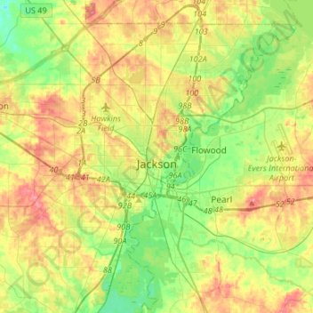
Name: Jackson topographic map, elevation, terrain.
Location: Jackson, Hinds County, Mississippi, United States (32.19550 -90.32993 32.41244 -90.06362)
Average elevation: 96 m
Minimum elevation: 59 m
Maximum elevation: 142 m
Other topographic maps
Click on a map to view its topography, its elevation and its terrain.
Rolling Meadows
United States > Mississippi > Hinds County > Jackson
Rolling Meadows, Jackson, Hinds County, Mississippi, 39158, United States
Average elevation: 92 m