
Make a donation
Gear up for your next adventure:
As an Amazon Associate, this site earns from qualifying purchases at no extra cost to you.
Saltsburg topographic map
Click on the map to display elevation.
Make a donation
Gear up for your next adventure:
As an Amazon Associate, this site earns from qualifying purchases at no extra cost to you.
About this map
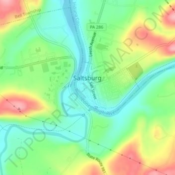
Name: Saltsburg topographic map, elevation, terrain.
Location: Saltsburg, Indiana County, Pennsylvania, United States (40.48095 -79.45411 40.48899 -79.44086)
Average elevation: 300 m
Minimum elevation: 250 m
Maximum elevation: 380 m
Make a donation
Gear up for your next adventure:
As an Amazon Associate, this site earns from qualifying purchases at no extra cost to you.
Other topographic maps
Click on a map to view its topography, its elevation and its terrain.
Robinson
United States > Pennsylvania > Indiana County > West Wheatfield Township
Average elevation: 397 m
Make a donation
Gear up for your next adventure:
As an Amazon Associate, this site earns from qualifying purchases at no extra cost to you.
Make a donation
Gear up for your next adventure:
As an Amazon Associate, this site earns from qualifying purchases at no extra cost to you.