
Gore topographic map
Interactive map
Click on the map to display elevation.
About this map
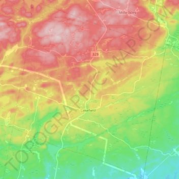
Name: Gore topographic map, elevation, terrain.
Location: Gore, Argenteuil, Laurentides, Quebec, J8H 3W8, Canada (45.70545 -74.32792 45.82414 -74.18301)
Average elevation: 270 m
Minimum elevation: 146 m
Maximum elevation: 401 m
Other topographic maps
Click on a map to view its topography, its elevation and its terrain.
Mont Cole
Canada > Quebec > Argenteuil > Grenville-sur-la-Rouge
Mont Cole, Grenville-sur-la-Rouge, Argenteuil, Laurentides, Quebec, Canada
Average elevation: 260 m