
MacDowell Lake topographic map
Click on the map to display elevation.
About this map
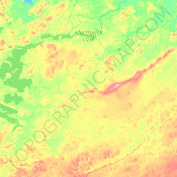
Name: MacDowell Lake topographic map, elevation, terrain.
Average elevation: 386 m
Minimum elevation: 344 m
Maximum elevation: 453 m
Other topographic maps
Click on a map to view its topography, its elevation and its terrain.
Burditt Lake
Canada > Ontario > Kenora District > Unorganized Kenora District
Average elevation: 367 m
Cardinal (Lac) Lake
Canada > Ontario > Kenora District > Unorganized Kenora District
Average elevation: 392 m
Hudson Bay Lowlands
Canada > Ontario > Kenora District > Unorganized Kenora District
Average elevation: 17 m
Big Island Lake
Canada > Ontario > Kenora District > Unorganized Kenora District
Average elevation: 430 m
Carroll Lake
Canada > Ontario > Kenora District > Unorganized Kenora District
Average elevation: 338 m
Clearwater Bay
Canada > Ontario > Kenora District > Unorganized Kenora District
Average elevation: 334 m
Wabauskang 21
Canada > Ontario > Kenora District > Unorganized Kenora District
Average elevation: 368 m
Dingwall Island
Canada > Ontario > Kenora District > Unorganized Kenora District
Average elevation: 325 m
Granite Lake
Canada > Ontario > Kenora District > Unorganized Kenora District
Average elevation: 355 m
Gordon Island
Canada > Ontario > Kenora District > Unorganized Kenora District
Average elevation: 349 m
Grindstone Lake
Canada > Ontario > Kenora District > Unorganized Kenora District
Average elevation: 371 m
Warwick Lake
Canada > Ontario > Kenora District > Unorganized Kenora District
Average elevation: 341 m
Slate Islands
Canada > Ontario > Kenora District > Unorganized Kenora District
Average elevation: 322 m
Nine Mile Lake
Canada > Ontario > Kenora District > Unorganized Kenora District
Average elevation: 413 m
Chisholm Island
Canada > Ontario > Kenora District > Unorganized Kenora District
Average elevation: 323 m
Muskeg River
Canada > Ontario > Kenora District > Unorganized Kenora District
Average elevation: 357 m
Mackey Island
Canada > Ontario > Kenora District > Unorganized Kenora District
Average elevation: 336 m
Muskeg River
Canada > Ontario > Kenora District > Unorganized Kenora District
Average elevation: 363 m
Tablerock Lake
Canada > Ontario > Kenora District > Unorganized Kenora District
Average elevation: 384 m
Little Boulder Lake
Canada > Ontario > Kenora District > Unorganized Kenora District
Average elevation: 359 m
Cameron Island
Canada > Ontario > Kenora District > Unorganized Kenora District
Average elevation: 338 m