Geolocate

Casper topographic map

Click on the map to display elevation.

About this map
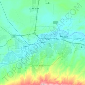
Name: Casper topographic map, elevation, terrain.

Location: Casper, Natrona County, Wyoming, United States (42.79129 -106.43497 42.90753 -106.21571)

Average elevation: 1,635 m

Minimum elevation: 1,546 m

Maximum elevation: 2,010 m

Other topographic maps

Click on a map to view its topography, its elevation and its terrain.
Midwest

United States > Wyoming > Natrona County

Average elevation: 1,482 m

Gear up for your next adventure:

📖Australian Bush Survival Books - Local knowledge on finding water and surviving the outback
🍴Titanium Spork & Cutlery - Indestructible and feather-light eating utensils
🍳Ultralight Camping Stoves - Boil water quickly for meals using minimal fuel
🚁Camera Drones with GPS - Capture aerial views of the landscape to compare with topo maps
🧦Merino Wool Hiking Socks - Moisture-wicking socks to prevent blisters during long topographic surveys

As an Amazon Associate, this site earns from qualifying purchases at no extra cost to you.