
Thank you for supporting this site ❤️
Make a donation
Make a donation
Gear up for your next adventure:
As an Amazon Associate, this site earns from qualifying purchases at no extra cost to you.
Casal Monastero topographic map
Click on the map to display elevation.
Thank you for supporting this site ❤️
Make a donation
Make a donation
Gear up for your next adventure:
As an Amazon Associate, this site earns from qualifying purchases at no extra cost to you.
About this map
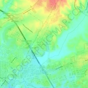
Name: Casal Monastero topographic map, elevation, terrain.
Location: Casal Monastero, Rome, Roma Capitale, Lazio, 00131, Italy (41.92596 12.58107 41.96596 12.62107)
Average elevation: 41 m
Minimum elevation: 18 m
Maximum elevation: 80 m
Thank you for supporting this site ❤️
Make a donation
Make a donation
Gear up for your next adventure:
As an Amazon Associate, this site earns from qualifying purchases at no extra cost to you.
Other topographic maps
Click on a map to view its topography, its elevation and its terrain.
Parco degli Acquedotti
Italy > Lazio > Roma Capitale > Rome > Osteria del Curato
Average elevation: 62 m