
Gershasen topographic map
Interactive map
Click on the map to display elevation.
About this map
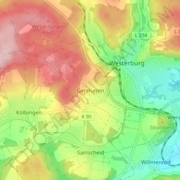
Name: Gershasen topographic map, elevation, terrain.
Average elevation: 396 m
Minimum elevation: 299 m
Maximum elevation: 501 m
Other topographic maps
Click on a map to view its topography, its elevation and its terrain.
Sainscheid
Deutschland > Rheinland-Pfalz > Westerwaldkreis > Westerburg
Sainscheid, Westerburg, Westerwaldkreis, Rheinland-Pfalz, 56457, Deutschland
Average elevation: 379 m