
Krauthausen topographic map
Interactive map
Click on the map to display elevation.
About this map
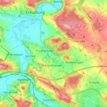
Name: Krauthausen topographic map, elevation, terrain.
Average elevation: 269 m
Minimum elevation: 188 m
Maximum elevation: 398 m
Other topographic maps
Click on a map to view its topography, its elevation and its terrain.
Eschenberg
Deutschland > Thüringen > Wartburgkreis > Treffurt
Eschenberg, Treffurt, Wartburgkreis, Thüringen, 99830, Deutschland
Average elevation: 382 m
Bad Salzungen
Deutschland > Thüringen > Wartburgkreis
Bad Salzungen, Wartburgkreis, Thüringen, Deutschland
Average elevation: 347 m