Geolocate

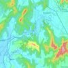
Karnala topographic map

Click on the map to display elevation.

About this map

Name: Karnala topographic map, elevation, terrain.

Location: Karnala, Panvel, Raigad, Maharashtra, 410207, India (18.88130 73.11812 18.88140 73.11822)

Average elevation: 130 m

Minimum elevation: 19 m

Maximum elevation: 409 m

Other topographic maps

Click on a map to view its topography, its elevation and its terrain.

Patalganga

India > Maharashtra > Panvel

Average elevation: 13 m

Patalganga

India > Maharashtra > Panvel > Apta

Average elevation: 85 m

Gear up for your next adventure:

⛺Lightweight Tents - Compact tents for backpacking
🎽Hiking Clothing - Breathable clothing for hiking
📱Tablet Tripod Mounts - Steady platforms for viewing digital maps or taking long exposures
🔦Powerful LED Headlamps - Hands-free lighting for night navigation and setting up camp after dark
🥶Thermal Beanies - Warm hats for cold hikes

As an Amazon Associate, this site earns from qualifying purchases at no extra cost to you.