
Walnut Park topographic map
Click on the map to display elevation.
About this map
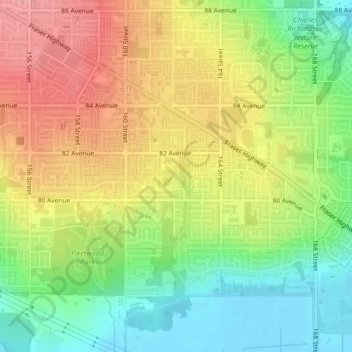
Name: Walnut Park topographic map, elevation, terrain.
Average elevation: 49 m
Minimum elevation: -1 m
Maximum elevation: 100 m
Other topographic maps
Click on a map to view its topography, its elevation and its terrain.
Serpentine Heights Park
Canada > British Columbia > Metro Vancouver Regional District > Surrey
Average elevation: 59 m
Surrey Lake
Canada > British Columbia > Metro Vancouver Regional District > Surrey
Average elevation: 26 m
South Surrey
Canada > British Columbia > Metro Vancouver Regional District > Surrey
Average elevation: 28 m
Cloverdale
Canada > British Columbia > Metro Vancouver Regional District > Surrey
Average elevation: 24 m
Guildford
Canada > British Columbia > Metro Vancouver Regional District > Surrey
Average elevation: 46 m
Surrey--Newton
Canada > British Columbia > Metro Vancouver Regional District > Surrey
Average elevation: 71 m
Green Timbers Lake
Canada > British Columbia > Metro Vancouver Regional District > Surrey
Average elevation: 95 m
Campbell Heights Biodiversity Preserve
Canada > British Columbia > Metro Vancouver Regional District > Surrey
Average elevation: 28 m
South Surrey
Canada > British Columbia > Metro Vancouver Regional District > Surrey
Average elevation: 28 m
Cresent Rock Beach
Canada > British Columbia > Metro Vancouver Regional District > Surrey
Average elevation: 29 m
South Surrey
Canada > British Columbia > Metro Vancouver Regional District > Surrey
Average elevation: 28 m