
Baute topographic map
Interactive map
Click on the map to display elevation.
About this map
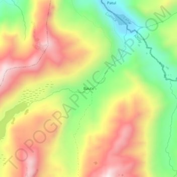
Name: Baute topographic map, elevation, terrain.
Location: Baute, Sayausí, Cuenca, Azuay, Équateur (-2.74498 -79.25220 -2.70498 -79.21220)
Average elevation: 4,013 m
Minimum elevation: 3,628 m
Maximum elevation: 4,391 m
Other topographic maps
Click on a map to view its topography, its elevation and its terrain.
Chippla
Équateur > Azuay > Cuenca > San Pedro de Yumate
Chippla, San Pedro de Yumate, Molleturo, Cuenca, Azuay, Équateur
Average elevation: 2,619 m