
Western Bay of Plenty District topographic map
Interactive map
Click on the map to display elevation.
About this map
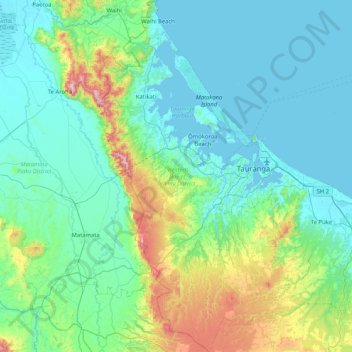
Name: Western Bay of Plenty District topographic map, elevation, terrain.
Location: Western Bay of Plenty District, Bay of Plenty, New Zealand (-38.02682 175.79485 -37.37320 176.60295)
Average elevation: 143 m
Minimum elevation: 0 m
Maximum elevation: 911 m
Other topographic maps
Click on a map to view its topography, its elevation and its terrain.
Lake Rotoiti
New Zealand > Bay of Plenty > Rotorua Lakes District > Rotoiti > Hinehopu
Average elevation: 349 m
Papamoa Hills Regional Park
New Zealand > Bay of Plenty > Western Bay of Plenty District
Average elevation: 58 m