
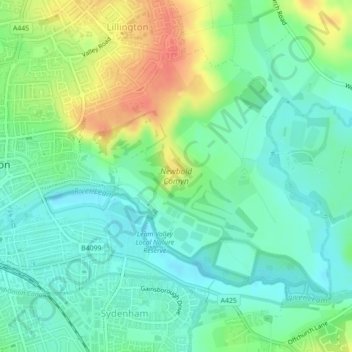
Royal Leamington Spa topographic map
Interactive map
Click on the map to display elevation.
About this map
Name: Royal Leamington Spa topographic map, elevation, terrain.
Average elevation: 66 m
Minimum elevation: 48 m
Maximum elevation: 99 m
Other topographic maps
Click on a map to view its topography, its elevation and its terrain.
West Midlands
United Kingdom > England > Warwickshire
West Midlands, Warwickshire, West Midlands Combined Authority, England, United Kingdom
Average elevation: 113 m
Nuneaton
United Kingdom > England > Warwickshire > Nuneaton and Bedworth
Nuneaton, Nuneaton and Bedworth, Warwickshire, England, CV11 5AB, United Kingdom
Average elevation: 101 m
Edgehill
United Kingdom > England > Warwickshire > Stratford-on-Avon > Radway
Edgehill, Ratley and Upton CP, Radway, Stratford-on-Avon, Warwickshire, England, OX15 6EB, United Kingdom
Average elevation: 157 m
Ratley
United Kingdom > England > Warwickshire > Stratford-on-Avon
Ratley, Stratford-on-Avon, Warwickshire, England, OX15 6DS, United Kingdom
Average elevation: 163 m
Warwick
United Kingdom > England > Warwickshire
Warwick, Warwickshire, England, United Kingdom
Average elevation: 87 m
Binley Woods CP
United Kingdom > England > Warwickshire > Rugby
Binley Woods CP, Rugby, Warwickshire, England, United Kingdom
Average elevation: 86 m
Lower Quinton
United Kingdom > England > Warwickshire > Stratford-on-Avon
Lower Quinton, Stratford-on-Avon, Warwickshire, England, CV37 8UZ, United Kingdom
Average elevation: 64 m
Nuneaton Common
United Kingdom > England > Warwickshire > Nuneaton and Bedworth
Nuneaton Common, Whittleford, Nuneaton and Bedworth, Warwickshire, England, United Kingdom
Average elevation: 127 m
Ryton Pools Country Park
United Kingdom > England > Warwickshire > Rugby
Ryton Pools Country Park, Ryton on Dunsmore CP, Rugby, Warwickshire, England, CV8 3BG, United Kingdom
Average elevation: 82 m
Sherbourne
United Kingdom > England > Warwickshire > Warwick
Sherbourne, Warwick, Warwickshire, England, United Kingdom
Average elevation: 56 m
Preston Green
United Kingdom > England > Warwickshire > Stratford-on-Avon
Preston Green, Stratford-on-Avon, Warwickshire, England, B95 5DP, United Kingdom
Average elevation: 88 m
Priors Marston
United Kingdom > England > Warwickshire > Stratford-on-Avon
Priors Marston, Stratford-on-Avon, Warwickshire, England, CV47 7RR, United Kingdom
Average elevation: 151 m
Spernal
United Kingdom > England > Warwickshire > Stratford-on-Avon
Spernal, Spernall, Stratford-on-Avon, Warwickshire, England, B80 7ET, United Kingdom
Average elevation: 73 m
Haseley Knob
United Kingdom > England > Warwickshire > Warwick > Wroxall
Haseley Knob, Beausale, Haseley, Honiley and Wroxall, Wroxall, Warwick, Warwickshire, England, CV35 7NL, United Kingdom
Average elevation: 117 m
Farnborough CP
United Kingdom > England > Warwickshire > Stratford-on-Avon
Farnborough CP, Stratford-on-Avon, Warwickshire, England, United Kingdom
Average elevation: 143 m
Church End
United Kingdom > England > Warwickshire > North Warwickshire > Ansley CP
Church End, Ansley CP, North Warwickshire, Warwickshire, England, CV10 0QR, United Kingdom
Average elevation: 151 m
Chessetts Wood
United Kingdom > England > Warwickshire > Warwick > Lapworth
Chessetts Wood, Lapworth, Warwick, Warwickshire, England, B94 6ET, United Kingdom
Average elevation: 115 m
Botley Hill
United Kingdom > England > Warwickshire > Stratford-on-Avon
Botley Hill, Stratford-on-Avon, Warwickshire, England, B95 5QY, United Kingdom
Average elevation: 101 m
Withybrook CP
United Kingdom > England > Warwickshire > Rugby
Withybrook CP, Rugby, Warwickshire, England, United Kingdom
Average elevation: 115 m
Newbold on Avon
United Kingdom > England > Warwickshire > Rugby
Newbold on Avon, Rugby, Warwickshire, England, CV21 1HQ, United Kingdom
Average elevation: 98 m
Butlers Marston
United Kingdom > England > Warwickshire > Stratford-on-Avon
Butlers Marston, Stratford-on-Avon, Warwickshire, England, United Kingdom
Average elevation: 93 m
Long Itchington
United Kingdom > England > Warwickshire > Stratford-on-Avon
Long Itchington, Stratford-on-Avon, Warwickshire, England, CV47 9PL, United Kingdom
Average elevation: 80 m
Rugby
United Kingdom > England > Warwickshire
Rugby, Warwickshire, England, United Kingdom
Average elevation: 112 m
Bubbenhall
United Kingdom > England > Warwickshire > Warwick
Bubbenhall, Warwick, Warwickshire, England, United Kingdom
Average elevation: 78 m
Arrow
United Kingdom > England > Warwickshire > Stratford-on-Avon
Arrow, Stratford-on-Avon, Warwickshire, England, B49 5PJ, United Kingdom
Average elevation: 61 m
Willey
United Kingdom > England > Warwickshire
Willey, Warwickshire, England, United Kingdom
Average elevation: 123 m
Little Wolford
United Kingdom > England > Warwickshire > Stratford-on-Avon
Little Wolford, Stratford-on-Avon, Warwickshire, England, CV36 5NB, United Kingdom
Average elevation: 103 m
Atherstone
United Kingdom > England > Warwickshire > North Warwickshire
Atherstone, North Warwickshire, Warwickshire, England, CV9 1JN, United Kingdom
Average elevation: 101 m
Stratford-on-Avon
United Kingdom > England > Warwickshire > Stratford-on-Avon
Stratford-on-Avon, Warwickshire, West Midlands, England, United Kingdom
Average elevation: 108 m
Oversley Wood
United Kingdom > England > Warwickshire > Stratford-on-Avon > Alcester > Exhall
Oversley Wood, Alcester, Exhall, Stratford-on-Avon, Warwickshire, England, United Kingdom
Average elevation: 64 m
Merevale Lake
United Kingdom > England > Warwickshire > North Warwickshire > Atherstone
Merevale Lake, Merevale CP, Atherstone, North Warwickshire, Warwickshire, England, United Kingdom
Average elevation: 119 m
Astley CP
United Kingdom > England > Warwickshire > North Warwickshire
Astley CP, North Warwickshire, Warwickshire, England, United Kingdom
Average elevation: 138 m
Curdworth Locks
United Kingdom > England > Warwickshire > North Warwickshire > Kingsbury > Curdworth CP
Curdworth Locks, Curdworth CP, Kingsbury, North Warwickshire, Warwickshire, England, B76 0DG, United Kingdom
Average elevation: 80 m
Wood End
United Kingdom > England > Warwickshire > North Warwickshire
Wood End, North Warwickshire, Warwickshire, England, CV7 8QG, United Kingdom
Average elevation: 137 m
Cranhill
United Kingdom > England > Warwickshire > Stratford-on-Avon > Ardens Grafton
Cranhill, Temple Grafton CP, Ardens Grafton, Stratford-on-Avon, Warwickshire, England, B50 4LW, United Kingdom
Average elevation: 57 m
Napton Hill
United Kingdom > England > Warwickshire > Stratford-on-Avon
Napton Hill, Stratford-on-Avon, Warwickshire, England, CV47 8PG, United Kingdom
Average elevation: 103 m
Hunningham
United Kingdom > England > Warwickshire > Warwick
Hunningham, Warwick, Warwickshire, England, United Kingdom
Average elevation: 73 m
Lighthorne
United Kingdom > England > Warwickshire > Stratford-on-Avon
Lighthorne, Stratford-on-Avon, Warwickshire, England, United Kingdom
Average elevation: 105 m
Southam CP
United Kingdom > England > Warwickshire > Stratford-on-Avon
Southam CP, Stratford-on-Avon, Warwickshire, England, United Kingdom
Average elevation: 91 m
River Tame
United Kingdom > England > Warwickshire
River Tame, Warwickshire, West Midlands Combined Authority, England, B68 0HQ, United Kingdom
Average elevation: 113 m
Burton Dassett Hills Country Park
United Kingdom > England > Warwickshire > Stratford-on-Avon > Northend > Burton Dassett CP
Burton Dassett Hills Country Park, Burton Dassett CP, Northend, Stratford-on-Avon, Warwickshire, West Midlands, England, United Kingdom
Average elevation: 132 m
Ashow
United Kingdom > England > Warwickshire > Warwick
Ashow, Warwick, Warwickshire, England, United Kingdom
Average elevation: 69 m
Barton-on-the-Heath
United Kingdom > England > Warwickshire > Stratford-on-Avon
Barton-on-the-Heath, Stratford-on-Avon, Warwickshire, England, United Kingdom
Average elevation: 130 m
Churchover CP
United Kingdom > England > Warwickshire > Rugby
Churchover CP, Rugby, Warwickshire, England, United Kingdom
Average elevation: 115 m
Shipston-on-Stour
United Kingdom > England > Warwickshire > Stratford-on-Avon
Shipston-on-Stour, Stratford-on-Avon, Warwickshire, England, CV36 4AJ, United Kingdom
Average elevation: 83 m
Chadshunt
United Kingdom > England > Warwickshire > Stratford-on-Avon
Chadshunt, Chadshunt CP, Stratford-on-Avon, Warwickshire, England, CV35 0EH, United Kingdom
Average elevation: 105 m
Ryton Wood
United Kingdom > England > Warwickshire > Rugby > Ryton-on-Dunsmore
Ryton Wood, Ryton on Dunsmore CP, Ryton-on-Dunsmore, Rugby, Warwickshire, England, United Kingdom
Average elevation: 89 m
Monks Kirby CP
United Kingdom > England > Warwickshire > Rugby
Monks Kirby CP, Rugby, Warwickshire, England, United Kingdom
Average elevation: 117 m
Shelfield
United Kingdom > England > Warwickshire > Stratford-on-Avon
Shelfield, Aston Cantlow CP, Stratford-on-Avon, Warwickshire, England, B49 6JW, United Kingdom
Average elevation: 87 m
Harborough Magna CP
United Kingdom > England > Warwickshire > Rugby
Harborough Magna CP, Rugby, Warwickshire, England, United Kingdom
Average elevation: 106 m