
East Orange topographic map
Interactive map
Click on the map to display elevation.
About this map
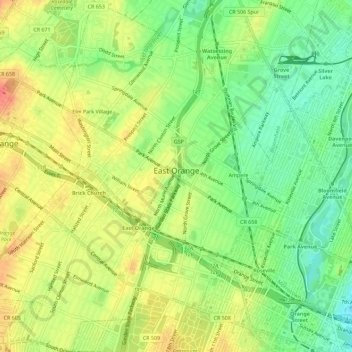
Name: East Orange topographic map, elevation, terrain.
Location: East Orange, Essex County, New Jersey, United States (40.74514 -74.23828 40.78814 -74.18981)
Average elevation: 49 m
Minimum elevation: 20 m
Maximum elevation: 78 m
Other topographic maps
Click on a map to view its topography, its elevation and its terrain.
Short Hills
United States > New Jersey > Essex County > Millburn > Short Hills
Average elevation: 98 m