
Thank you for supporting this site ❤️
Make a donation
Make a donation
Gear up for your next adventure:
As an Amazon Associate, this site earns from qualifying purchases at no extra cost to you.
Matisi B topographic map
Click on the map to display elevation.
Thank you for supporting this site ❤️
Make a donation
Make a donation
Gear up for your next adventure:
As an Amazon Associate, this site earns from qualifying purchases at no extra cost to you.
About this map
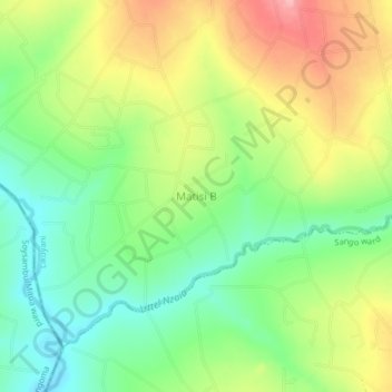
Name: Matisi B topographic map, elevation, terrain.
Location: Matisi B, Nzoia ward, Likuyani, Kakamega County, Western, Kenya (0.77572 35.06149 0.81572 35.10149)
Average elevation: 1,793 m
Minimum elevation: 1,736 m
Maximum elevation: 1,869 m
Thank you for supporting this site ❤️
Make a donation
Make a donation
Gear up for your next adventure:
As an Amazon Associate, this site earns from qualifying purchases at no extra cost to you.